![](/images/other/stat-length.png)
![Tour Zu Fuß Unter Zerekwe - Naučná stezka Čeřínek - Photo](https://media.geolcdn.com/t/1900/400/2e65a863-f40a-4380-8034-537cfc0ccd11.jpeg&format=pjpeg&maxdim=2)
Naučná stezka Čeřínek
SityTrail - itinéraires balisés pédestres
Tous les sentiers balisés d’Europe GUIDE+
![Länge](/images/other/stat-length.png)
Länge
6,1 km
![Maximale Höhe](https://static1.geolcdn.com/siteimages/upload/files/1508320355ic_sort_altitude_max_24dp.png)
Maximale Höhe
714 m
![Positive Höhendifferenz](https://static1.geolcdn.com/siteimages/upload/files/1508320355ic_sort_den_pos_24dp.png)
Positive Höhendifferenz
190 m
![Km-Effort](/images/other/stat-length.png)
Km-Effort
8,7 km
![Min. Höhe](https://static1.geolcdn.com/siteimages/upload/files/1508320355ic_sort_altitude_min_24dp.png)
Min. Höhe
553 m
![Negative Höhendifferenz](https://static1.geolcdn.com/siteimages/upload/files/1508320355ic_sort_den_neg_24dp.png)
Negative Höhendifferenz
191 m
![Boucle](https://static1.geolcdn.com/siteimages/upload/files/16400158638029165_repeat_loop_refresh_sync_direction_icon.png)
Boucle
Ja
Kennzeichnung
Erstellungsdatum :
2025-02-07 02:28:08.988
Letzte Änderung :
2025-02-07 02:28:08.988
![Zu Fuß](https://static1.geolcdn.com/sitytour/trail-icons/100.png)
1h58
Schwierigkeit : Einfach
![Scannen Sie diesen QR-Code, um die Tour in der SityTrail-Anwendung zu öffnen](https://capi.geolives.com/qq0zvz2zws4bq2lad0pu/sitytour/trails/4344462/qr.png?size=200)
Kostenlosegpshiking-Anwendung
Über SityTrail
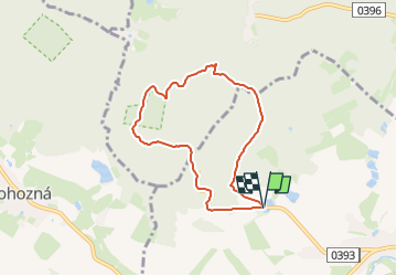
Tour Zu Fuß von 6,1 km verfügbar auf Südosten, Region Hochland, Unter Zerekwe. Diese Tour wird von SityTrail - itinéraires balisés pédestres vorgeschlagen.
Beschreibung
Tour erstellt von cz:KČT.
Ort
Land:
Czech Republic
Region :
Südosten
Abteilung/Provinz :
Region Hochland
Kommune :
Unter Zerekwe
Standort:
Unknown
Gehen Sie:(Dec)
Gehen Sie:(UTM)
531764 ; 5466314 (33U) N.
Kommentare
Touren in der Umgebung
![Tour Zu Fuß Fußdorf - Pěší trasy Stříbrného pomezí - Photo](https://media.geolcdn.com/t/375/260/f62c2463-8c7b-424e-b544-ad13aecf3616.jpeg&format=jpg&maxdim=2)
![Zu Fuß Zu Fuß](https://static1.geolcdn.com/sitytour/trail-icons/100.png)
Pěší trasy Stříbrného pomezí
Zu Fuß
Einfach
Fußdorf,
Südosten,
Region Hochland,
Czech Republic
![](/images/other/stat-length.png)
4,7 km | 6 km-effort
1h 21min
![](https://static1.geolcdn.com/siteimages/upload/files/16400158638029165_repeat_loop_refresh_sync_direction_icon.png)
Nein
![Tour Zu Fuß Iglau - Hornická NS - Photo](https://media.geolcdn.com/t/375/260/33f088f6-724a-4b8d-8b3f-e0856137b157.jpeg&format=jpg&maxdim=2)
![Zu Fuß Zu Fuß](https://static1.geolcdn.com/sitytour/trail-icons/100.png)
Hornická NS
Zu Fuß
Einfach
Iglau,
Südosten,
Region Hochland,
Czech Republic
![](/images/other/stat-length.png)
5,7 km | 8,1 km-effort
1h 49min
![](https://static1.geolcdn.com/siteimages/upload/files/16400158638029165_repeat_loop_refresh_sync_direction_icon.png)
Nein
![Tour Zu Fuß Teltsch - NS Otokara Březiny - Photo](https://media.geolcdn.com/t/375/260/703d2f25-c711-47da-b690-62cdf36f0fa8.jpeg&format=jpg&maxdim=2)
![Zu Fuß Zu Fuß](https://static1.geolcdn.com/sitytour/trail-icons/100.png)
NS Otokara Březiny
Zu Fuß
Medium
Teltsch,
Südosten,
Region Hochland,
Czech Republic
![](/images/other/stat-length.png)
19,3 km | 25 km-effort
5h 37min
![](https://static1.geolcdn.com/siteimages/upload/files/16400158638029165_repeat_loop_refresh_sync_direction_icon.png)
Nein
![Tour Zu Fuß Pilgrams - [Č] Pelhřimov - Nový Rychnov - Photo](https://media.geolcdn.com/t/375/260/3b527b44-da93-45e2-822d-496afe7c79e4.jpeg&format=jpg&maxdim=2)
![Zu Fuß Zu Fuß](https://static1.geolcdn.com/sitytour/trail-icons/100.png)
[Č] Pelhřimov - Nový Rychnov
Zu Fuß
Einfach
Pilgrams,
Südosten,
Region Hochland,
Czech Republic
![](/images/other/stat-length.png)
14,6 km | 19,9 km-effort
4h 31min
![](https://static1.geolcdn.com/siteimages/upload/files/16400158638029165_repeat_loop_refresh_sync_direction_icon.png)
Nein
![Tour Zu Fuß Humpoletz - [Ž] Humpolec - Kletečná - Photo](https://media.geolcdn.com/t/375/260/61c79774-ac44-4316-bc7b-59e2527b1d21.jpeg&format=jpg&maxdim=2)
![Zu Fuß Zu Fuß](https://static1.geolcdn.com/sitytour/trail-icons/100.png)
[Ž] Humpolec - Kletečná
Zu Fuß
Einfach
Humpoletz,
Südosten,
Region Hochland,
Czech Republic
![](/images/other/stat-length.png)
8,1 km | 10,4 km-effort
2h 21min
![](https://static1.geolcdn.com/siteimages/upload/files/16400158638029165_repeat_loop_refresh_sync_direction_icon.png)
Nein
![Tour Zu Fuß Studená - [Ž] Studená - za Vrškem - Photo](https://media.geolcdn.com/t/375/260/dbf7c158-72a2-4a80-bde9-4b16abef1677.jpeg&format=jpg&maxdim=2)
![Zu Fuß Zu Fuß](https://static1.geolcdn.com/sitytour/trail-icons/100.png)
[Ž] Studená - za Vrškem
Zu Fuß
Einfach
Studená,
Südwesten,
Südböhmische Region,
Czech Republic
![](/images/other/stat-length.png)
4 km | 5,5 km-effort
1h 14min
![](https://static1.geolcdn.com/siteimages/upload/files/16400158638029165_repeat_loop_refresh_sync_direction_icon.png)
Nein
![Tour Zu Fuß Triesch - Naučná stezka Špičák - Photo](https://media.geolcdn.com/t/375/260/1776db07-bb82-416b-924a-edd1e2a86df9.jpeg&format=jpg&maxdim=2)
![Zu Fuß Zu Fuß](https://static1.geolcdn.com/sitytour/trail-icons/100.png)
Naučná stezka Špičák
Zu Fuß
Einfach
Triesch,
Südosten,
Region Hochland,
Czech Republic
![](/images/other/stat-length.png)
10,8 km | 14,9 km-effort
3h 22min
![](https://static1.geolcdn.com/siteimages/upload/files/16400158638029165_repeat_loop_refresh_sync_direction_icon.png)
Nein
![Tour Zu Fuß Nový Rychnov - [Z] Křemešnický okruh - Photo](https://media.geolcdn.com/t/375/260/f11d492b-ddb0-4c5d-b682-83aa126fd453.jpeg&format=jpg&maxdim=2)
![Zu Fuß Zu Fuß](https://static1.geolcdn.com/sitytour/trail-icons/100.png)
[Z] Křemešnický okruh
Zu Fuß
Einfach
Nový Rychnov,
Südosten,
Region Hochland,
Czech Republic
![](/images/other/stat-length.png)
5,1 km | 7,5 km-effort
1h 42min
![](https://static1.geolcdn.com/siteimages/upload/files/16400158638029165_repeat_loop_refresh_sync_direction_icon.png)
Ja
![Tour Zu Fuß Červená Řečice - [Ž] Červená Řečice - Na vyhlídce - Photo](https://media.geolcdn.com/t/375/260/d705b93f-8824-4978-8f66-916e162f23b1.jpeg&format=jpg&maxdim=2)
![Zu Fuß Zu Fuß](https://static1.geolcdn.com/sitytour/trail-icons/100.png)
[Ž] Červená Řečice - Na vyhlídce
Zu Fuß
Einfach
Červená Řečice,
Südosten,
Region Hochland,
Czech Republic
![](/images/other/stat-length.png)
7,6 km | 9,8 km-effort
2h 13min
![](https://static1.geolcdn.com/siteimages/upload/files/16400158638029165_repeat_loop_refresh_sync_direction_icon.png)
Nein